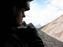
 What is this rocky prairie? This photo was taken just seconds before the clouds moved in completely to take away the view of the summit dome. My volcanological companions and I visited Volcan Baru´s amphitheater during an uncharacteristically rainy week. After exploring the area of La Yeguada with PCVs Karinne and Noah, we took the Interamericana, headed west, then drove due north to the volcano. This was a good time to visit the largest known debris avalanche in Central America. The photo above is a view into the amphitheater of Volcan Baru. We are standing on a lahar surface and looking roughly East up into the dome complex. Too bad about the weather, the summit antennas are already hidden by the incoming rain.
Since we had the benefit of several great geological minds, we took
 time to look at a phenomenon very different than lava flows. Debris avalanches are dramatic, but very rare events at volcanoes. By rare, I mean that they don´t happen every day but many volcanoes around the world have collapse features like what you can see at Baru. Some preliminary studies describe this particular deposit as the largest in Central America. What does that mean? At this point it just means that a whole lot of mountain fell down many thousands of years ago.
Want to know more about hummocks? Go here: USGS VHP
Events like this are very interesting for a number of reasons but I´m interested in them because they scoop out a volcano and create new terrain. After walking around Mount St. Helens for a while in 2004, I developed a particular interest in the features called hummocks. They represent coherent blocks that tumbled, slid, or floated along with the rest of the debris that made up the flanks of a volcano. Here´s one outcrop of a hummock but it represents a blocky phase and lacks the multicolored characteristic typical of most hummocks:
 (Bill, Guillermo, and Karinne for scale)
In the fan of deposits from Baru, you can find these hummocks and start to get an idea of how the collapse took place- this could be good thesis material.
Thanks for taking the time to visit and brainstorm project plans, everybody - this was a valuable series of fieldtrips!


